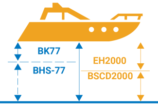
In Estonia, EVRS heights are marked with the abbreviation EH2000, with EH referring to Estonian Heights and 2000 to the land uplift of Fennoscandia in 2000. The Baltic Sea states agreed to start using on the charts of the Baltic Sea and in navigational information a common vertical chart datum called the Baltic Sea Chart Datum 2000 (BSCD2000), so all charts and reference books that give heights and depths according to EH2000 are now marked as Baltic Sea Chart Datum 2000 EH2000.
In simple terms, Estonia switched from the Kronstadt Tide Gauge to the Amsterdam Ordnance Datum.
Why the switch?
With the new height system, all Baltic Sea states that are members of the European Union can use navigational charts and port and waterway data according to the same system.
There is no more need for calculations to switch from one height system to another when navigators are visiting countries that use the same system, and no need for considering the differences between the height systems adopted in foreign countries when navigating between their ports, for instance. A common height system also simplifies the planning and executing of international projects.
What has changed in navigational information?
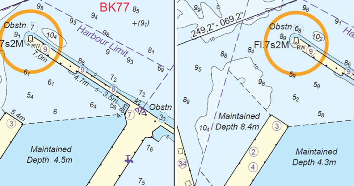
Databases switched to the new system within a three-month transition period (from 1 January to 31 March 2018). Issuing navigational charts in accordance with the new system takes years, as it is a labour-intensive and time-consuming process. During the transition period navigational charts in both vertical reference systems are used simultaneously. Navigational charts compiled according to both systems are suitable for navigation. It is simply necessary to make sure which system the particular chart or reference book is based on. The reference to the vertical system used is added to all charts, reference books and GIS applications containing data on depths.
Estonian Electronic Navigational Charts (ENC) showing progress in transfer from BHS77 to BSCD2000(EH2000)
Estonian Paper Charts showing progress in transfer from BHS77 to BSCD2000 (EH2000)
What changed for ports?
Ports have to review all their data media that contain data on depths (such as their websites together with all figures, surveys and plans, port rules, etc.) and make sure that all data on depths have a reference to the particular height system used.
What is different for navigators?
Navigators have to consider which system is used on charts when reading depth data.
Nothing is different for navigators; they simply must consider which system is used on the charts they use. The sea contains the same amount of water as before, but it is important to remember that the depths on navigational charts are given according to the vertical chart datum of the current height system. Thus, the depths given on the chart and its height system, as well as the current water level in that system must be considered while navigating. Information regarding water level is distributed by ports and made available on the Estonian Weather Service website www.ilmateenistus.ee. In order to convert the depth data given in the Baltic height system BHS-77 into the data that corresponds to the new height system EH2000, the Estonian Land Board made available on its website a converter which enables the user to recalculate the depths according to the location.
Last updated: 24.07.2025